THÔNG BÁO VÀ MÔ TẢ VỀ VIỆC CẤM KHAI THÁC ĐỘNG VẬT CÓ VỎ
SỐ 021L-187, WHITEHOUSE CREEK VÀ VÙNG LÂN CẬN
CÓ HIỆU LỰC TỪ NGÀY 15 THÁNG 10 NĂM 2026
Căn cứ theo Tiêu đề 28.2, Chương 8, các điều 28.2-803 đến 28.2-808, điều 32.1-20, và điều 2.2-4002, B.16 của Bộ Luật Virginia:
1. The “Notice and Description of Shellfish Area Condemnation Number 021L-187, Whitehouse Creek and Vicinity,” effective 15 December 2025, is cancelled effective 15 October 2026.
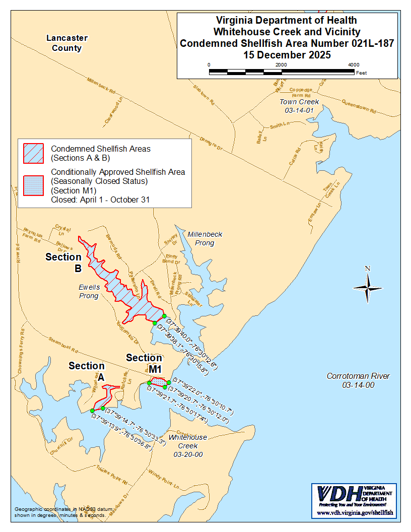
2. Condemned Shellfish Area Number 021L-187, shown as Sections A and B, is hereby established effective 15 October 2026. It shall be unlawful for any person, firm, or corporation to take shellfish from these areas for any purpose, except by permit granted by the Marine Resources Commission, as provided in § 28.2-810 of the Code of Virginia. The boundaries of these areas are shown on the map titled “Whitehouse Creek, Condemned Shellfish Area Number 021L-187, 15 October 2026” which is a part of this notice.
3. Conditionally Approved Shellfish Area (Seasonally Closed Status) Number 021L-187, shown as Section M1, is hereby established effective 15 October 2026, and shall remain in force annually thereafter for the period beginning the first day of April through the last day of October until rescinded. It shall be unlawful for any person, firm or corporation to take shellfish from this area during such period for any purpose while in the closed status, except by permit granted by the Marine Resources Commission, as provided in § 28.2-810 of the Code of Virginia. The boundaries of this area are shown on the map titled “Whitehouse Creek, Condemned Shellfish Area Number 021L-187, 15 October 2026” which is part of this notice.
4. Sở Y tế sẽ tiếp nhận, xem xét và phản hồi các kiến nghị của bất kỳ cá nhân quan tâm nào vào bất kỳ lúc nào liên quan đến việc xem xét lại hoặc sửa đổi lệnh này.
RANH GIỚI CỦA KHU VỰC BỊ THU HỒI SỐ 021L-187
A. The condemned area shall include that portion of Whitehouse Creek upstream of a line drawn between latitude/longitude map coordinate (37°39'14.9",-76°30'31.2") and map coordinate (37°39'10.0",-76°30'29.3").
B. The condemned area shall include all of the Ewells and Millenbeck Prongs of Whitehouse Creek upstream of a line drawn between latitude/longitude map coordinate (37°39'29.9",-76°30'04.2") and map coordinate (37°39'29.9",-76°30'04.8").
Thứ1. Khu vực được phê duyệt có điều kiện (đóng cửa theo mùa) sẽ bao gồm phần Whitehouse Creek nằm trong đất liền của đường kẻ nối giữa tọa độ bản đồ vĩ độ/kinh độ (37°39'21.7",-76°30'17.4"), tọa độ bản đồ (37°39'20.7",-76°30'12.0"), và tọa độ bản đồ (37°39'22.0",-76°30'10.7").